

Каталог▲▼
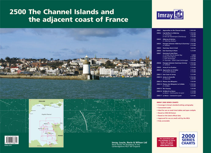
2500 The Channel Islands and adjacent coast of France
Артикул: 00456229
в желания В наличии
Автор: Imray
Издательство: Imray (все книги издательства)
Место издания: England
ISBN: 9781846238611
Год: 2017
С этим товаром покупают
 2500.8 St Malo Approaches
  2700.1 Liverpool Bay and Anglesey
 In new A2 atlas format suitable for use on small chart tables and in the cockpit. Printed on high quality cartridge paper,
This product is also available wiro bound, please use code IC2500-3W.
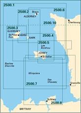
1. Approaches to the Channel Islands (1: 500 000)
2. Cap Barfleur to Alderney (1: 150 000) Plans Cherbourg (1:40 000) Port de Chantereyne (Cherbourg) (1:10 000)
3. Alderney & Burhou (1: 25 000) Plan Alderney Harbour (1:12 500)
4. Passages Between Alderney & Guernsey (1: 150 000) Plan Di?lette (1:15 000)
5. Guernsey, Herm & Sark (1: 60 000)
6. East Guernsey & Herm (1: 25 000)
7. Guernsey & Sark Plans (various scales) Plans St Peter Port & Havelet Bay (1:6000) Beaucette Marina (1:10 000) Sark Anchorages (1:25 000) Guernsey - South Coast Anchorages (1:25 000)
8. Passages Between Guernsey & Jersey (1: 150 000) Plan Carteret (1:22 500)
9. Jersey & Les ?crehou (1: 75 000)
10. Approaches to St Helier (1: 30 000) Plan St Helier Harbour (1:15 000)
11. East Coast of Jersey (1: 25 000)
12. Jersey to Granville (1: 150 000) Plan Granville (1:30 000)
13. Plateau des Minquiers (1: 50 000)
14. Plateau des Minquiers to St-Malo (1: 150 000) Plan St-Malo Approaches (1:55 000)
15. ?les Chausey (1: 25 000)
16. St-Malo & La Rance (1: 15 000)
17. La Rance - Cancaval to Lyvet (1: 25 000)
For this 2017 edition the latest depth surveys have been applied. There has been general updating throughout. This edition has tidal stream information is included.
Отзывы покупателей (0)
У этого товара пока нет отзывов. Поделитесь впечатлением первым.